
On Thursday, Christchurch NZ almost eclipsed its previous record for the first day of spring. According to weather forecasters, New Zealand will see one of the hottest September ever.
Christchurch New Zealand Surpasses 21C On The First Day Of Spring
At the airport, Christchurch recorded a peak temperature of 21.6C on Thursday, just missing the warmest September 1 on record of 21.8C in 2020. The frigid weather is still present in garden city, nevertheless. Next week is likely to be cooler, with highs in Christchurch on Monday and Tuesday only projected to reach 10C.
On Thursday, blossoming blooms could be seen in front of Christchurch’s Riverside Market.

The second-warmest spring in NZ on record was last year, according to NIWA, and the warmest spring on record was in 1988.
After La Nina regained power last month, it forecasts a warmer and drier spring for Canterbury. The south experiences warmer and drier conditions than typical because of the Pacific Ocean weather trend known as La Nia.
You can explore A Guide To Summer And Other Seasons In New Zealand
NIWA Published Its Seasonal Climate Outlook From September To November
La Nia conditions are “extremely likely” to persist, with a 75–80% chance; therefore, they will play a significant role in the springtime climate. A “triple-dip” La Nia, defined as three consecutive La Nia events from 2020 to 2022, is “extremely likely,” according to NIWA, and would be the first such event from 1998 to 2000. A “battleground” of feature pressures, with sporadic subtropical lows and robust high-pressure belts, may be present this spring, it noted. Predictions of seasonal rainfall are thus “especially hard.”
A sub-tropical low in the first week of September, according to NIWA, may increase the likelihood of significant rainfall in the northern North Island. In the third week of September, there’s a chance of another subtropical low, which might bring more rain, possibly heavy rain, to some areas of the nation.
However, there will be protracted dry spells following a brief cold spell in early September, and temperatures will “quite likely” be warmer than usual for much of the nation.
Regional Forecasts For Spring In NZ
Temperatures are “extremely likely” to be above average in Northland, Auckland, Waikato, and Bay of Plenty, with a 70% likelihood of this happening. It will occasionally be unusually warm and humid due to increased northeasterly winds and maritime heatwave conditions.
Occasionally, sub-tropical low-pressure systems may track towards these areas, increasing the chance of heavy rain, according to NIWA, for example, during the first and third week of September. Additionally, the northeasterly winds may cause dry spells in southwest regions like Waikato.
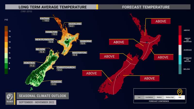
Temperatures are also “very likely” to be above average across the central and lower North Island, Taranaki, Whanganui, Manawatu, and Wellington, with a 70% likelihood. Here, stronger northeasterly winds and conditions similar to a marine heatwave may lead to more sunshine and warmer temperatures.
The likelihood of temperatures being above average is likewise “quite likely” (65%) for Gisborne, Hawke’s Bay, and Wairarapa. Higher humidity levels, greater cloud cover, and warmer nocturnal temperatures could result from stronger northeasterly winds.
According to NIWA, the possibility of more frequent onshore breezes in certain areas may result in more wet days. The probability of heavy rain may also occasionally be increased by subtropical lows, especially for northern areas like northern Hawke’s Bay and Gisborne.
Temperatures are also “very likely” to be above average in Tasman, Nelson, Marlborough, and Buller, with a 60% likelihood of this happening. It will occasionally be warm for the time of year here due to stronger northeasterly winds and maritime heatwave conditions.
Occasionally, sub-tropical lows may also move towards these areas, increasing the likelihood of heavy rain, as was the case in the third week of September. Dry spells could also result from fewer westerly winds, especially in western regions like Tasman and Buller.
Temperatures are also “very likely” to be above average in Southland, the West Coast, the alps and foothills, and inland Otago (65% likelihood). Warmer temperatures and longer periods of greater sunshine may result from stronger northeasterly breezes.
Longer dry spells could result from fewer westerly breezes, according to NIWA. However, there can also be sporadic heavy fronts with lots of moisture.
Temperatures are “most likely” to be above average in coastal Canterbury and east Otago, with a 55% likelihood of this happening. A decrease in westerly winds may result in fewer warm days, but an increase in onshore winds may bring on more clouds and warmer temperatures at night.
Longer dry spells may be caused by numerous anticyclones, according to NIWA, albeit these may occasionally be broken up by subtropical lows that bring moisture from the north.